Complete Maps and Navigation Guide to Lamma Island
Geographic Overview of Lamma Island
Lamma Island (南丫島, pronounced "Laam-maa Island" in Cantonese) is Hong Kong's third-largest island, covering approximately 13.55 square kilometers. Long but irregularly shaped and quite hilly, the coastline of Lamma Island has for thousands of years provided landing places and natural harbors for its inhabitants. The island stretches roughly 8 kilometers from north to south, with a dramatic narrow waist that divides it into northern and southern sections.
The majority of the small population (approximately 5,000 residents) lives in the northerly Yung Shue Wan village, which is adjacent to the distinctive Lamma Power Station with its three towering smokestacks. The second most popular village is Sok Kwu Wan, located on the eastern part of the narrow waist of the island, which features an almost enclosed natural harbor that has protected fishing boats for centuries.
Major Villages and Settlements
Yung Shue Wan (榕樹灣) - The Main Village
Location: Northwestern coast of Lamma Island
Population: Approximately 3,000 residents
Character: The island's largest settlement and main ferry terminal, Yung Shue Wan combines traditional village life with international influences from a significant expatriate community. The village features the island's main commercial street, diverse restaurants, shops, and cultural attractions.
Key Landmarks:
- Yung Shue Wan Ferry Pier - Main arrival point from Central
- Main Street - Primary commercial and dining area
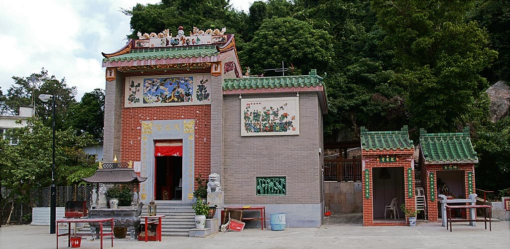
- Tin Hau Temple - Traditional Chinese temple dedicated to the sea goddess
- Yung Shue Wan Beach - Small beach near the village center
- Wind Power Station - Visible renewable energy landmark
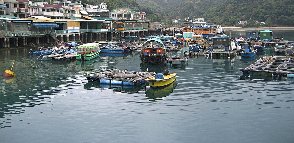
Sok Kwu Wan (索罟灣) - The Seafood Village
Location: Eastern side of the island's narrow waist
Population: Approximately 400 residents
Character: A traditional fishing village famous throughout Hong Kong for its seafood restaurants. The natural harbor is lined with floating fish farms and traditional restaurants specializing in fresh seafood dining.
Key Features:
- Sok Kwu Wan Ferry Pier - Direct ferry service from Central
- Seafood Restaurant Strip - Famous dining destination
- Fish Farms - Traditional aquaculture operations
- Tin Hau Temple - Historic temple with harbor views
- Lamma Fisherfolk's Village - Cultural heritage center
Smaller Communities and Settlements
Lo So Shing (蘆鬚城): A small village near the southern beaches, primarily residential with limited visitor facilities. Notable for its proximity to Lo So Shing Beach and traditional village architecture.
Sha Po (沙埔): A small community north of Yung Shue Wan, featuring traditional village houses and quiet residential streets. Home to some local shops and restaurants.
Mo Tat Wan (模達灣): A tiny coastal settlement accessible by ferry, known for its beachfront restaurant and peaceful atmosphere. Popular for day trips and beach dining.
Pak Kok Tsuen (白角村): A small village on the western coast, accessible by ferry from Aberdeen. Features traditional fishing community lifestyle and quiet residential areas.
Topographical Features and Natural Landmarks
Mountain Peaks and Hills
Mount Stenhouse (山地塘): At 353 meters above sea level, this is Lamma Island's highest point. The summit offers spectacular 360-degree views of Hong Kong's skyline, other outlying islands, and the South China Sea. The hiking trail to the summit is challenging but rewarding for experienced hikers.
Ling Kok Shan (嶺角山): A secondary peak offering panoramic views and easier hiking access than Mount Stenhouse. Popular for sunrise and sunset photography.
Northern Hills: Gentler elevations around Yung Shue Wan, including the area around the Wind Power Station, offering moderate hiking with good views of Hong Kong Island.
Coastal Features and Beaches
Hung Shing Yeh Beach (洪聖爺灣): The island's main swimming beach, located between Yung Shue Wan and Sok Kwu Wan. Features lifeguard services, changing facilities, and barbecue areas. The beach faces west, offering spectacular sunset views.
Lo So Shing Beach (蘆鬚城灣): A more secluded beach on the southern coast, known for its clear water and peaceful atmosphere. Popular for snorkeling and nature photography. No lifeguard services, so swimming requires caution.
Sham Wan Beach (深灣): Hong Kong's only sea turtle nesting beach, located on the southern coast. Access is restricted during nesting season (June-October) to protect endangered green sea turtles. When open, it offers pristine natural beauty and educational opportunities.
Power Station Beach: A small beach near the Lamma Power Station, less crowded but with industrial views. Suitable for quiet walks and bird watching.
Transportation and Ferry Terminals
Ferry Routes and Schedules
Central to Yung Shue Wan:
- Journey Time: 20-25 minutes
- Frequency: Every 30-60 minutes
- Operating Hours: 6:30 AM to 11:30 PM (midnight on weekends)
- Operator: Hong Kong & Kowloon Ferry (HKKF)
Central to Sok Kwu Wan:
- Journey Time: 30-35 minutes
- Frequency: Every 1-2 hours
- Operating Hours: 7:15 AM to 10:30 PM
- Operator: Hong Kong & Kowloon Ferry (HKKF)
Aberdeen Routes:
- Aberdeen to Yung Shue Wan (via Pak Kok Tsuen): 35-40 minutes total
- Aberdeen to Sok Kwu Wan (via Mo Tat Wan): 35-40 minutes total
- Aberdeen to Mo Tat Wan: 25 minutes direct
Hiking Trails and Walking Paths
Family Walk Trail (5km)
Route: Yung Shue Wan → Hung Shing Yeh Beach → Wind Power Station → Sok Kwu Wan
Duration: 90 minutes to 2 hours
Difficulty: Easy to Moderate
Highlights: Coastal views, renewable energy education, beach access, village culture
Path Conditions: Well-maintained concrete and paved paths, suitable for families with children over 6 years
Mount Stenhouse Summit Trail
Route: Various access points leading to 353m summit
Duration: 2-3 hours round trip
Difficulty: Challenging
Highlights: Panoramic views, diverse flora and fauna, photography opportunities
Requirements: Good hiking shoes, water, and reasonable fitness level
Kamikaze Cave Historical Trail
Route: Detour from Family Walk trail
Duration: 30-45 minutes additional
Difficulty: Moderate
Historical Significance: WWII Japanese naval hideout site
Access: 10-minute walk from main trail with basic path markings
Infrastructure and Facilities
Healthcare and Emergency Services
Lamma Island Clinic: Located in Yung Shue Wan, providing basic medical services
Emergency Access: Helicopter landing pad near clinic for serious emergencies
Emergency Numbers: 999 for all emergencies (police, fire, ambulance)
Utilities and Communications
Electricity: Provided by Lamma Power Station and Hong Kong Electric
Water Supply: Combination of reservoirs and mainland Hong Kong supply
Internet and Mobile: Good coverage from major Hong Kong providers
Waste Management: Regular collection services, recycling programs
Environmental and Conservation Areas
Protected Areas
Sham Wan Turtle Beach: Protected habitat for endangered green sea turtles
Feng Shui Woods: Traditional forest areas with cultural and ecological significance
Marine Protected Zones: Surrounding waters with fishing restrictions and coral protection
Flora and Fauna
Native Plants: Diverse subtropical vegetation including bamboo, banyan trees, and coastal shrubs
Wildlife: Birds, butterflies, small mammals, and marine life including occasional dolphin sightings
Conservation Efforts: Active programs to protect endangered species and restore native habitats
Interactive Map and Navigation Tools
View Larger Map
Navigation Tips for Visitors
Getting Your Bearings
Orientation: The three tall smokestacks of Lamma Power Station serve as the island's most visible landmark and navigation reference point
Village Identification: Yung Shue Wan is the busier, more cosmopolitan village; Sok Kwu Wan is smaller and focused on seafood dining
Trail Markers: Well-maintained signs in English and Chinese mark major trails and distances
Mobile Navigation
GPS Coordinates: Lamma Island center approximately 22.2083° N, 114.1306° E
Mobile Apps: Google Maps, Apple Maps, and local Hong Kong apps provide accurate navigation
Offline Maps: Download maps before travel as mobile coverage can be spotty in remote areas
Physical Landmarks for Navigation
From Ferry Piers: Clear signage in multiple languages directs visitors to major attractions
Trail Junctions: Distance markers and directional signs at all major path intersections
Emergency Markers: Location markers along trails for emergency response reference
Seasonal Considerations for Navigation
Typhoon Season (May-November): Some trails may be closed during severe weather; ferry services suspended during T8+ signals
Turtle Nesting Season (June-October): Sham Wan Beach access restricted to protect nesting green sea turtles
Peak Tourism Periods: Expect crowded trails and longer ferry queues during holidays and weekends
A comprehensive network of well-maintained walking paths makes it possible to visit any part of the island. However, the steep hills make some paths unsuitable for those with mobility limitations. Most main routes are accessible, with alternative easier paths available for visitors who prefer less challenging terrain.